Sunset experiences are absolutely free, every single day(depending on Mother Nature.) I took a quick video of this unique “golden hour” on an October 2013 autumn day using a Phantom Camera Drone. The clouds and horizon provided a gorgeous aerial perspective of the event. My favorite colors come at sunset especially near water where you get shimmering reflections of the sky. Ideally, the Delta's water surface offers some of the best mirror-like “glass” conditions. Photographers, wakeboarders, and skiers love the “glassy” delta.
Me and my family love watching sunsets as much as we can here in Stockton. It reminds us of our travel and vacations or simply a quick getaway from urban life. It is natures closure to a blessed day. Most importantly, sunsets always remind me of the appreciation of life. Beautifully expressed by my young son who has followed his daddy saying “goodnight sun, see you tomorrow”, "catch you on the other side sunshine" and/or “tomorrow will be a brand new day."
4 Delta Sunset Drive-Up Locations in Stockton, CA:
The optimal location to view sunsets is when you have a clear horizon with all three elements: land, sky and water together. Stockton is inland and the Delta is it's perfect neighbor. Although many roads in Stockton have limited or restricted access, here are our locations in Stockton to view the great central valley sunsets and still go home in time for dinner:
Rio Blanco Road
Empire Tract Road
West March Lane
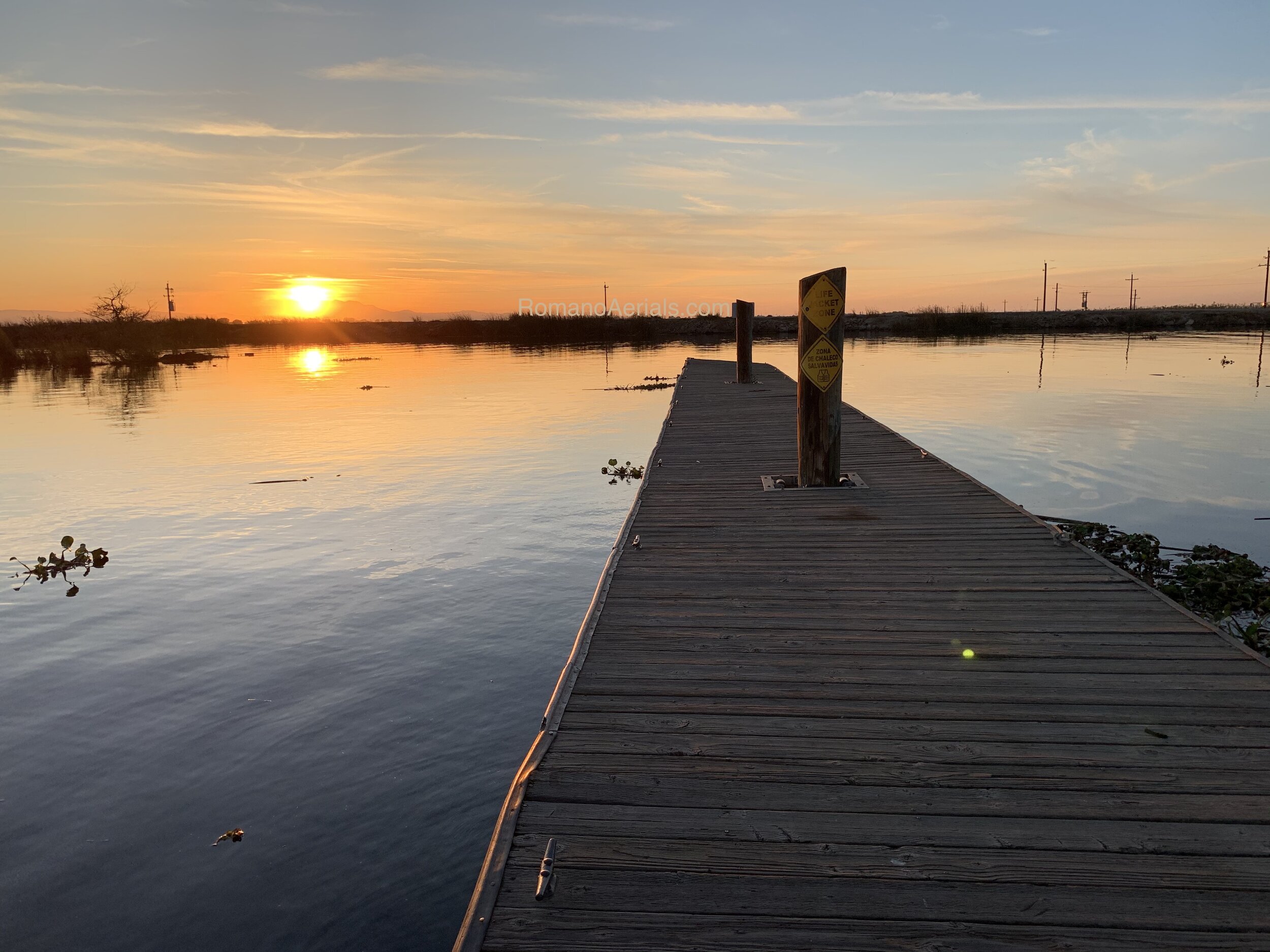
Village West Marina
Extra - Windmill Cove Resort
Extra - Neugerbauer Road
Here are the details on the locations::
1. Rio Blanco Road: Secret Spot for Two at Paradise Point Marina
Take Eight Mile Road, past the shopping center, west to Rio Blanco Road. It is the first road you will see before the first bridge. If you make a right, going north, you can pull over for a bit, with the water way below you to enjoy the sunset. I took an aerial sunset video here.
If you turn left, going south, on Rio Blanco Road, it leads you to Paradise Point Marina. Park in front of the store or on the lower lot across the store. Walk around the store to the outdoor wooden patio covers. Picnic tables are available. Continue down the short path to the water. If someone did not move it, you may find a surprise setting for two or a picnic table. It is the perfect secret spot for a glass of wine and sundown with someone. Congrats, you found "Paradise Point"!
Best Secret Sunset Spot for Two!!
If you continue on Eight Mile Road, go to the 2nd bridge, near King Island Resort. You will find a green steel rusted bridge which has been a fantastic photo subject in many sunset and artistic astrophotography. You can park at the resort, on the levee, and walk to the bridge.

King Island Bridge
King Island Launch Ramp Dock

1000 miles of waterways in the San Joaquin Delta
2. Empire Tract Road (very end of 8 Mile road)
This is at the very end of Eight Mile Road west past two bridges from the I-5 freeway. Drive 8-10 minutes west till you get to the end of Eight Mile Road. Slow down as you go up the levee. You do not want to end up in the water or on the private cable ferry crossing. Empire Tract Road is left of the old Herman & Helen’s Marina. Turn left and you will be driving on the levee with the sun and waterway to your right. At the very end of Empire Tract Road, just a couple more minutes past the ships, you will find an old wooden launch ramp. At this point the river opens up to the main channel, the San Joaquin River. This is the most remote and accessible Delta vantage point within Stockton. Park safely off the road, stop the engine, listen to nature and find some peace as sundown approaches.
Points of interest:
Couple ships being refurbished - one is The MV Aurora and the other, The Fir. Learn more about the ships and Herman and Helens from this story in the Record.
Some photographers have used the ships and views off Empire Tract Road for artistic photography of the stars and constellations.
At the Main Channel: You can see the two channel markers #11 and #12 across the way. This is where the big ships pass to get to The Port of Stockton. Use this schedule to catch them.
Across the water from the wooden ramp and small dock is an island called Little Venice Island, a secret wedding venue. Check out the photos!
Around the 4th of July, Empire Tract Road is the best drive-up vantage point to view the Baron Hilton Fireworks Show if you do not have a boat. Get a spot early because it can get packed.
You may catch a freighter in your sunset shot. Southern point of Empire Tract Road
CAUTION: Please drive carefully on Eight Mile road west. It is a typical Delta roadway where the pavement is uneven because of the soft peat soil underneath. Be aware of your speed! A reminder that the San Joaquin Delta is a place to slow your life down to enjoy the beauty and splendor of nature. Take it slow or plan on bringing a snack as you wait for the "golden hour." Respect the Delta and always pick up after yourself so someone else can enjoy it too.
Update (Oct. 2019): Homeless and RV squatters have setup camp in the area near the old wooden launch ramp. Please be aware of your surroundings.
SJ County Sheriff Non-Emergency: (209) 468-4400 Emergency: (209) 468-4421
3. West March Lane
At the In-N-Out Burger exit off March Lane, head west for just a few minutes before Ladd’s Marina and Boat Launch.
Two options.
1. Park just outside the entrance of Ladd's Marina and walk the levee. You will see a small grassy area to the left. Park your car there and look for the turnstile gate. Enter to access levee. Joggers, walkers and fisherman frequent the area. On your walk, you can see the boat docks on the right and the rear of homes on the left. Keep walking on the levee till you get to the main channel. You may even catch large ocean freighter navigating the river. Here is the Port of Stockton Ship Schedule. If you keep walking the levee, you will see the start of the Calaveras River. Look across the river and you will see a small Statue of Liberty replica. If you continue along the levee pathway it will end up to the other turnstile gate on Brookside Road. Note the times at the turnstiles when the gate or else you may get locked-in.
2. You can pay a small fee(prices are at the entry) and enter Buckley Cove Park. Park anywhere near the curb adjacent to the waterway, walk past the grass to the rocky shoreline for nice sunset views. You may also see boats, sailboats, and the Stockton Rowing Club. Visit their Facebook Page. If interested in boating, bring your chair and check out the launch ramp action. There are a few Boat Launch Tips to follow.
——
Update June 2016. The original March Lane Levee Road. This access was fenced off and closed in 2016, bummer!
After the last stoplight(Riverbrook Dr.), make a right turn, and drive up the levee road. Carefully drive(lots of potholes) on levee road around the pond and pass the marina to your left. Keep going till you get to the main channel. Careful around that curve! Look for a covered metal shed opposite the waterway. That is the landmark where the river starts to widen and the prime location for great photos. This stretch of road is the one of the closest and convenient delta levee access in Stockton. The road is shared by fisherman, transients, couples in cars and families out enjoying time near the waterline. Park your car and take in the delta views during all seasons! COOL TIP: Look down the waterway and find the lighted shipping channel markers on both sides of the levee. Now look further down the channel. See the two tall towers spanning the wire across the channel. A great photo is the "Sunset Touchdown." The sun shimmers down the river during the month of July-Aug.
"Sunset Touchdown" - Taken off March Lane on a warm and breezy July day.
End of March Lane. Walk down levee to the waterline. Taken March 2012.
4. Village West Marina
This is a quick, in-town location, off of Benjamin Holt Dr. with a tranquil view of the Delta. There is a tule berm, gas dock, and kayak shed in the way. The tule berm adds a beautiful silhouette to photos. To get the BEST unobstructed water view, go down to the gas pump dock and walk to the end to capture a wider Delta sunset shot. On a very clear day, you can see windmills in the distance and view of Mount Diablo. To get to Village West Marina head west on Ben Holt and follow the sign up to the parking lot(before the tennis courts.) Parking can be crowded in the small circle lot on weekend nights. Make a left and park toward the covered boat docks before the blue security gate. There are a few picnic benches with views of the restaurant boat docks. Enjoy the small grassy area underneath the pine trees to relax. Grab a bite to eat on the outside patio of Garlic Brothers Restaurant. Or… grab a burger special at Bob's at The Marina.

Picnic Tables at Village West Marina. Always occupied. Get there early!

Relax to watch the boat activity or just contemplate and dream.
Village West Marina, Stockton, CA. Taken September 2013.
Patio dining with great Delta sunsets happen at Garlic Brothers. Aerial taken April 2013.
5. Windmill Cove Resort (just outside Stockton)
Another great sunset location is a 15-20 min. drive WEST on Hwy 4, Charter Way(Martin Luther King Dr.) Make a right turn on Inland Dr to McDonald Rd, north on Holt Rd, right on Windmill Cove Rd. to Windmill Cove Resort. They have a large viewing deck overlooking the waterway. Bands play often on summer weekends. Walk to the windmill, bring a blanket or lawn chair to relax on the grass. Enjoy all the boating action on the water during the summer months and enjoy their Taco Tuesdays and the secret swim beach toward the east side of the resort.
Enjoy your Sunsets. Life is Good!
Summertime shot at Windmill Cove Resort and Marina, just outside Stockton off Hwy 4.
6. Neugerbauer Rd. - Widest Delta Levee access in Stockton.
Same route to Windmill Cove but make a left when you get to the end of Holt Road. Go west when you get up the levee. Even though it is only about 15 min. away from Highway 5, Neugerbauer Road is one of the most secret and secluded drive-up Delta levee locations! You will see the widest part of the San Joaquin River in Stockton and can see huge ships pass through here. <Port of Stockton Ship Schedule> When parking, find an open shoulder spot on the river side next to the rocks. There are some dirt areas wide enough to fit multiple cars. This place is absolutely ideal for night sky photography as there is no city light pollution. If you go during the day, park next to a shade tree and enjoy the sights and sounds of the Delta.

Take your sunset photography to a new perspective! With your own drone.
More Footage on RomanoAerials.com


Gallery | Drone Store | Drone Safety | GoPro Store | About Us
Insider Tips on Launching your boat at Stockton area marinas and boat ramps.